(为小屏幕设备进优化)

Szombathely
Savaria, the Roman city
Savaria, the Roman city
Szombathely (known as Savaria in Roman times) was the first city founded in Hungary, and it is the centre of Vas county. This city, situated at the foot of the Alps, got its name from the weekly markets which were held here on Saturdays. St Martin, one of Europe’s greatest saints of ancient times is from here. Even a Roman emperor, namely Septimus Severus, was chosen from here.

Since the main commercial route of Pannonia, the Amber Road, led through the city, the Romans first established a place for changing horses and carriages, and later a military camp. As time passed Savaria became a Roman city, and its inhabitants were now Roman citizens, which resulted in great developments. The provincial centre was of great importance and was visited by several Roman emperors.
During the persecution of Christians a number of religious people died a martyr’s death. For example, probably in order to deter his followers, St Quirinus, the bishop of Siscia was thrown into the swollen Gyöngyös Stream with a millstone round his neck.

The climax of Savaria’s growth was in the 4th century when its population increased greatly. Significant constructions were in progress, and churches, cathedrals, public spas, theatres and official buildings were established. Of these the most exquisite were the St Quirinus Cathedral and the Imperial Palace. The city looked like a miniature Rome in these times.
The Huns appeared in 377 with their modern fighting strategies. They could not be stopped even with the sacrifice of the prefect’s own army. Against the migration of nations, the city wall provided some protection for a while, but the king of the Huns, Attila seized the city between 441 and 445.

After several stormy centuries St Stephan gave the city to the episcopate of Győr in 1009. The Mongol invasion and the Turkish attack caused serious damages. Having besieged Vienna the Turkish army devastated the area, however the city wall served as some protection for the inhabitants.

During the Rákóczi' war of independence Szombathely sided with the prince, but the fierce fights resulted in the fact that it was sometimes ruled by the Hungarians, and at other times the Austrians.
But not only wars caused a lot of deaths, but the Black Death epidemics which followed them. More or less two thousand people fell prey to this illnes, consequently the city almost became depopulated. The deceased were replaced by neighbouring Germans. This resulted in the area losing its Hungarian character and the German influence becoming dominant. Although the city gained a foreign influence, it started to flourish. The bishop of the diocese, founded by Maria Theresa in 1777, launched great construction projects. He demolished the castle and its church, and then built the cathedral and the episcopal palace.

The episcopal cathedral
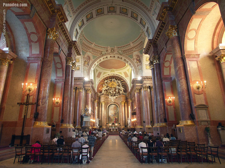
The Baroque style cathedral was built at the end of the 18th century and the beginning of the 19th century, dedicated to the Blessed Virgin Lady. Interestingly enough it was built to accomodate five thousand people, however in those times Szombathely only had two thousand and four hundred inhabitants. The former castle, which had been in a bad condition, used to stand here, was demolished when they announced the construction of the church and the episcopal palace.
St. Martin's Church (Szent Márton-templom)
According to the legend St Martin’s birthplace was located here, and in the 9th century a church was built on it. Now the monastery is attached to the southern side of the church.
特性,特征
类型:
城市,大城市
位置:
欧洲(大陆) > 匈牙利(国家) > 匈牙利西部(旅游区) > Vas megye (county)(州,县) > Alpokalja(地理区域)
GPS坐标的: 纬度 47°14'6",经度 16°37'18" (N47 14.1 - E16 37.3)
Szombathely - 照片画廊(23张照片)
您可能也有兴趣(相关网页):
目的地在旅遊指南:
Szombathely(23张照片)
Alpokalja(230张照片 + 1全景图像)
Vas megye (county)(499张照片 + 5全景图像)
匈牙利西部(985张照片 + 10全景图像)
匈牙利(27,287张照片 + 163全景图像)
并且还:
(在这里:Vas megye和Alpokalja)
Őrség National Park(83张照片)
Ják
Kám(99张照片)
Körmend(117张照片)
Kőszeg(33张照片 + 1全景图像)
Sárvár(79张照片 + 3全景图像)
Szentgotthárd(8张照片)
Körmend(117张照片)
Kőszeg(33张照片 + 1全景图像)
Bükfürdő(65张照片 + 1全景图像)
Sopron(57张照片)
这里每全景照片:
Szombathely(张照片)
Alpokalja(1张照片)
Vas megye (county)(5张照片)
匈牙利西部(10张照片)
匈牙利(163张照片)
欧洲(165张照片)
每一个正常的照片在这里:
Szombathely(23张照片)
Alpokalja(230张照片 / 6画廊)
Vas megye (county)(499张照片 / 13画廊)
匈牙利西部(985张照片 / 27画廊)
匈牙利(27,287张照片 / 462画廊)
欧洲(30,494张照片 / 523画廊)
与你的朋友分享!
等等


