(Optimeret til enheder med små skærme)

Nyíregyháza
The gateway to the East
The gateway to the East
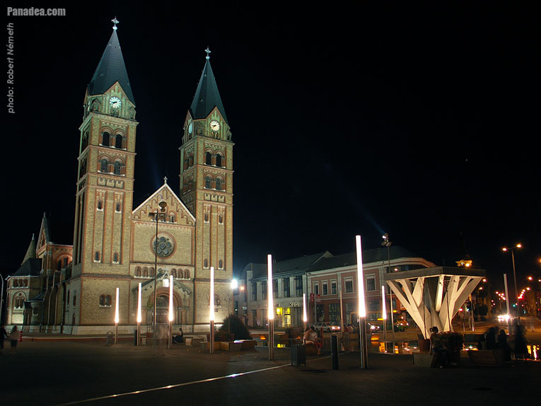
The city was first mentioned in the 13th century in the name Nyír. Then in 1236 its church was built, so the city’s name was supplemented with the second part. (The Hungarian word ‘egyház’ refers to an ecclesiastic building.) The city is often called ‘the gateway to the East” because since World War II it has been surrounded by the borders of three countries. It is the seventh largest city in Hungary and the economic centre of North East Hungary. A favourite destination of holidaymakers is Sóstó, which is not far from the city.

When the city was part of the Turkish Empire most of the population left. The ‘hajduk’ (late Hungarian mercenary soldiers) were settled in the city at the beginning of the 17th century.
The population of the city went on growing during Rákóczi’s War of Independence. In the 18th century Slav settlers moved here from Békés County in the South. By this time it had the largest population in the region, numbering 7500 people. The population continued to grow and further development took place. In the year 1786 it was given market town rights and allowed to hold four markets a year.

The 19th century proved to be the next turning point in its history. It managed to redeem itself by raising the sum needed to become free peasants. Thus the people did not belong to the Dessewfy and Károlyi families any more. Moreover, in 1837 it received a special royal privilege as well.
The present image of the inner city is shaped by the buildings from the late 19th and the early 20th century. For example the eclectic City Hall with Renaissance features, the V-shaped Takarékpalota (Bank Palace) and the Korona Hotel. In the works of the famous writer of the city, Gyula Krúdy, you can read about the narrow and winding streets, the small crumbling houses which were the characteristics of the city in the beginning of the 20th century. Unfortunately they do not exist any more.

Visitors will find plenty of cultural events during the summer season here as well. Of course it is advisable to inquire about the different programmes in advance so as to plan your journey around the most inviting ones.
Sóstó
Entertainment can be found not only in the centre, but out of the city as well. Not far from the city the Sóstó Wood (the lungs of Nyíregyháza) attracts visitors for a nice walk. Furthermore Sóstógyógyfürdő is also located here. The lake is made up of two parts; one of them is suitable for bathing and the other for rowing. The water in the lake comes from the 1000 metre deep hot water springs.

The Museum Village of Sóstó
The largest regional open-air ethnic museum in the country is located here. It is unusual in the fact that some of its buildings still function. For example there is a Calvinist mass held in the church on Sunday mornings, and you can be served in the shop, at the butcher’s and in the pub.

At organised demonstrations of craftsmen’s workshops, tourists can have an insight into the ins and outs of different trades. On certain days they can even taste local food.
The Zoo
This is the second largest zoo in Hungary after that of Budapest. Here, on this area of the lowlands, visitors can meet bears, elephants, monkeys or sharks. Altogether there are 150 species in specially designed enclosures imitating their natural habitat.
Egenskaber, karakteristika
Type:
Større by, storby
Placering:
Europa (Kontinent) > Ungarn (Land) > Nordlige ungarske slette (Észak-Alföld) (Turistregion) > Szabolcs-Szatmár-Bereg megye (county) (Provins)
GPS-koordinater: Bredde 47°57'11", Længde 21°43'36" (N47 57.18 - E21 43.6)
Nyíregyháza - Fotogalleri (38 billeder)
Du kan måske også være interesseret i (Relaterede sider):
Destinationer i rejseguide:
Nyíregyháza (38 billeder)
Szabolcs-Szatmár-Bereg megye (county) (687 billeder)
Nordlige ungarske slette (Észak-Alföld) (1 619 billeder + 7 panorama billeder)
Ungarn (27 287 billeder + 163 panorama billeder)
og derudover:
(ind her: Szabolcs-Szatmár-Bereg megye)
Dombrád (93 billeder)
Máriapócs (177 billeder)
Mátészalka (85 billeder)
Nagykálló (111 billeder)
Nyírbátor (183 billeder)
Alle panoramafoto her:
Nyíregyháza ( billeder)
Nordlige ungarske slette (Észak-Alföld) (7 billeder)
Ungarn (163 billeder)
Europa (165 billeder)
Hver normal foto her:
Nyíregyháza (38 billeder)
Szabolcs-Szatmár-Bereg megye (county) (687 billeder / 14 gallerier)
Nordlige ungarske slette (Észak-Alföld) (1 619 billeder / 26 gallerier)
Ungarn (27 287 billeder / 462 gallerier)
Europa (30 494 billeder / 523 gallerier)
https://www.panadea.com/da/guidebook/nyiregyhaza

Tilføj til Favoriter Tilføj til Bogmærker
Del med dine venner!
osv.
Alle rettigheder forbeholdt
- ©2010-2022
Neuronit Creative Studio - Mogyoród / Budapest / Ungarn


