
(Оптимизован за уређаје са малим екранима)
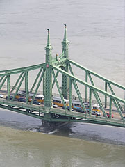
Liberty Bridge (aka Freedom Bridge, "Szabadság híd") - Будимпешта, Мађарска
Када кликнете:
Кликните на сликама!
-

The Liberty Bridge of Budapest ("Szabadság híd") over the Danube River and in front of the Gellért Hill ("Gellért-hegy")
Датум фотографисања: 20132013
Цреатед би: Robert Németh
Модел фотоапарата: Konica Minolta Dimage A200
Будимпешта, Мађарска
-

The Pest-side tower (pylon) of the Liberty Bridge ("Szabadság híd") in front of the Gellért Hill
Датум фотографисања: 20132013
Цреатед би: Robert Németh
Модел фотоапарата: Konica Minolta Dimage A200
Будимпешта, Мађарска
-

Former customs house at the Pest side of the Liberty Bridge ("Szabadság híd")
Датум фотографисања: 20132013
Цреатед би: Robert Németh
Модел фотоапарата: Konica Minolta Dimage A200
Будимпешта, Мађарска
-

The sight of the Liberty Bridge ("Szabadság híd") and the Buda Castle Quarter from the promenade on the Danube bank in Pest
Датум фотографисања: 20132013
Цреатед би: Robert Németh
Модел фотоапарата: Konica Minolta Dimage A200
Будимпешта, Мађарска
-

The view of the Liberty Bridge from the Pest bank of the Danube
Датум фотографисања: 20062006
Цреатед би: Robert Németh
Модел фотоапарата: Konica Minolta Dimage A200
Будимпешта, Мађарска
-

The Liberty Bridge ("Szabadság híd") over the Danube River, as seen from the Gellért Hill
Датум фотографисања: 20112011
Цреатед би: Robert Németh
Модел фотоапарата: Konica Minolta Dimage A200
Будимпешта, Мађарска
-

One of the ornate four-way lamp posts of the Liberty Bridge
In the background it is the Central Market Hall.
Датум фотографисања: 20132013
Цреатед би: Robert Németh
Модел фотоапарата: Konica Minolta Dimage A200
Будимпешта, Мађарска
-

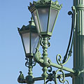
Ornate four-way lamp post on the Liberty Bridge ("Szabadság híd")
Датум фотографисања: 20132013
Цреатед би: Robert Németh
Модел фотоапарата: Konica Minolta Dimage A200
Будимпешта, Мађарска
-

Some lamps of the Liberty Bridge
Датум фотографисања: 20132013
Цреатед би: Robert Németh
Модел фотоапарата: Konica Minolta Dimage A200
Будимпешта, Мађарска
-

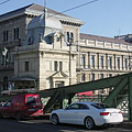
The other former customs house of the Liberty Bridge ("Szabadság híd"), in front of the main building of the Corvinus University
Датум фотографисања: 20132013
Цреатед би: Robert Németh
Модел фотоапарата: Konica Minolta Dimage A200
Будимпешта, Мађарска
-
The foot of the Gellért Hill viewed from the Liberty Bridge ("Szabadság híd")
Датум фотографисања: 20132013
Цреатед би: Robert Németh
Модел фотоапарата: Konica Minolta Dimage A200
Будимпешта, Мађарска
The foot of the Gellért Hill viewed from the Liberty Bridge ("Szabadság híd") - Будимпешта, Мађарска -
The end of the Liberty Bridge ("Szabadság híd") and the lower embankment on the Pest side of the river
Датум фотографисања: 20132013
Цреатед би: Robert Németh
Модел фотоапарата: Konica Minolta Dimage A200
Будимпешта, Мађарска
The end of the Liberty Bridge ("Szabadság híd") and the lower embankment on the Pest side of the river - Будимпешта, Мађарска -
The Pest-side end of the Liberty Bridge ("Szabadság híd")
Датум фотографисања: 20132013
Цреатед би: Robert Németh
Модел фотоапарата: Konica Minolta Dimage A200
Будимпешта, Мађарска
The Pest-side end of the Liberty Bridge ("Szabadság híd") - Будимпешта, Мађарска -
The view of the Liberty Bridge ("Szabadság híd") towards Buda
Датум фотографисања: 20132013
Цреатед би: Robert Németh
Модел фотоапарата: Konica Minolta Dimage A200
Будимпешта, Мађарска
The view of the Liberty Bridge ("Szabadság híd") towards Buda - Будимпешта, Мађарска -
The connection of the Liberty Bridge ("Szabadság híd") on the Pest riverside
Датум фотографисања: 20132013
Цреатед би: Robert Németh
Модел фотоапарата: Konica Minolta Dimage A200
Будимпешта, Мађарска
The connection of the Liberty Bridge ("Szabadság híd") on the Pest riverside - Будимпешта, Мађарска -
The Pest-side end of the Liberty Bridge ("Szabadság híd"), and the main building of the Corvinus University in the background
Датум фотографисања: 20132013
Цреатед би: Robert Németh
Модел фотоапарата: Konica Minolta Dimage A200
Будимпешта, Мађарска
The Pest-side end of the Liberty Bridge ("Szabadság híd"), and the main building of the Corvinus University in the background - Будимпешта, Мађарска -
Passers-by on the Liberty Bridge ("Szabadság híd")
Датум фотографисања: 20132013
Цреатед би: Robert Németh
Модел фотоапарата: Konica Minolta Dimage A200
Будимпешта, Мађарска
Passers-by on the Liberty Bridge ("Szabadság híd") - Будимпешта, Мађарска -
A tram on the Liberty Bridge
Датум фотографисања: 20132013
Цреатед би: Robert Németh
Модел фотоапарата: Konica Minolta Dimage A200
Будимпешта, Мађарска
A tram on the Liberty Bridge - Будимпешта, Мађарска -
The sight from the Libery Bridge northwards: the Danube River, the Gellért Hill, the Elisabeth Bridge and the Buda Castle
Датум фотографисања: 20132013
Цреатед би: Robert Németh
Модел фотоапарата: Konica Minolta Dimage A200
Будимпешта, Мађарска
The sight from the Libery Bridge northwards: the Danube River, the Gellért Hill, the Elisabeth Bridge and the Buda Castle - Будимпешта, Мађарска -
Old customs house, today museum with exhibition that presents the Danube bridges of Budapest
Датум фотографисања: 20132013
Цреатед би: Robert Németh
Модел фотоапарата: Konica Minolta Dimage A200
Будимпешта, Мађарска
Old customs house, today museum with exhibition that presents the Danube bridges of Budapest - Будимпешта, Мађарска -
Simplified coat of arms of Hungary on the Liberty Bridge ("Szabadság híd")
Датум фотографисања: 20132013
Цреатед би: Robert Németh
Модел фотоапарата: Konica Minolta Dimage A200
Будимпешта, Мађарска
Simplified coat of arms of Hungary on the Liberty Bridge ("Szabadság híd") - Будимпешта, Мађарска -
The Liberty Bridge ("Szabadság híd") to the direction of Buda
Датум фотографисања: 20132013
Цреатед би: Robert Németh
Модел фотоапарата: Konica Minolta Dimage A200
Будимпешта, Мађарска
The Liberty Bridge ("Szabadság híd") to the direction of Buda - Будимпешта, Мађарска -
Detail of the Liberty Bridge
Датум фотографисања: 20132013
Цреатед би: Robert Németh
Модел фотоапарата: Konica Minolta Dimage A200
Будимпешта, Мађарска
Detail of the Liberty Bridge - Будимпешта, Мађарска -
The green-painted Liberty Bridge ("Szabadság híd")
Датум фотографисања: 20132013
Цреатед би: Robert Németh
Модел фотоапарата: Konica Minolta Dimage A200
Будимпешта, Мађарска
The green-painted Liberty Bridge ("Szabadság híd") - Будимпешта, Мађарска -
The Pest-side pylon of the Libery Bridge ("Szabadság híd")
Датум фотографисања: 20132013
Цреатед би: Robert Németh
Модел фотоапарата: Konica Minolta Dimage A200
Будимпешта, Мађарска
The Pest-side pylon of the Libery Bridge ("Szabadság híd") - Будимпешта, Мађарска -
The surroundings of the Liberty Bridge on the Pest side of the river (embankment, Danube, bridge, etc.)
Датум фотографисања: 20132013
Цреатед би: Robert Németh
Модел фотоапарата: Konica Minolta Dimage A200
Будимпешта, Мађарска
The surroundings of the Liberty Bridge on the Pest side of the river (embankment, Danube, bridge, etc.) - Будимпешта, Мађарска -
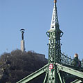
A tower (pylon) of the Liberty Bridge ("Szabadság híd") with the bronze sculpture of a falcon-like turul bird, as well as the Libery Statue on the Gellért Hill (in the distance)
Датум фотографисања: 20132013
Цреатед би: Robert Németh
Модел фотоапарата: Konica Minolta Dimage A200
Будимпешта, Мађарска
A tower (pylon) of the Liberty Bridge ("Szabadság híd") with the bronze sculpture of a falcon-like turul bird, as well as the Libery Statue on the Gellért Hill (in the distance) - Будимпешта, Мађарска -
One of the towers (pylons) of the Liberty Bridge ("Szabadság híd") with two turul bird sculptures on its top, and the Liberty Statue on the Gellért Hill in the background
Датум фотографисања: 20132013
Цреатед би: Robert Németh
Модел фотоапарата: Konica Minolta Dimage A200
Будимпешта, Мађарска
One of the towers (pylons) of the Liberty Bridge ("Szabadság híd") with two turul bird sculptures on its top, and the Liberty Statue on the Gellért Hill in the background - Будимпешта, Мађарска -
The Pest-side lower embankment, as well as the Liberty Bridge ("Szabadság híd") over River Danube
Датум фотографисања: 20132013
Цреатед би: Robert Németh
Модел фотоапарата: Konica Minolta Dimage A200
Будимпешта, Мађарска
The Pest-side lower embankment, as well as the Liberty Bridge ("Szabadság híd") over River Danube - Будимпешта, Мађарска -
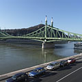
The Liberty Bridge ("Szabadság híd") over the river
Датум фотографисања: 20132013
Цреатед би: Robert Németh
Модел фотоапарата: Konica Minolta Dimage A200
Будимпешта, Мађарска
The Liberty Bridge ("Szabadság híd") over the river - Будимпешта, Мађарска -
Liberty Bridge ("Szabadság híd", formerly "Ferencz József híd", "Fővám téri híd") over River Danube
Датум фотографисања: 20062006
Цреатед би: Robert Németh
Модел фотоапарата: Konica Minolta Dimage A200
Будимпешта, Мађарска
Liberty Bridge ("Szabadság híd", formerly "Ferencz József híd", "Fővám téri híd") over River Danube - Будимпешта, Мађарска -
Liberty Bridge (in Hungarian "Szabadság híd"), as well as the Gellért Hotel and Gellért Bath in the distance
Датум фотографисања: 20062006
Цреатед би: Robert Németh
Модел фотоапарата: Konica Minolta Dimage A200
Будимпешта, Мађарска
Liberty Bridge (in Hungarian "Szabadság híd"), as well as the Gellért Hotel and Gellért Bath in the distance - Будимпешта, Мађарска -
Liberty Bridge ("Szabadság híd") over the flooded Danube, viewed from Gellért Hill
Датум фотографисања: 20062006
Цреатед би: Robert Németh
Модел фотоапарата: Konica Minolta Dimage A200
Будимпешта, Мађарска
Liberty Bridge ("Szabadság híd") over the flooded Danube, viewed from Gellért Hill - Будимпешта, Мађарска -
The Liberty Bridge ("Szabadság híd") and the flooding River Danube from Gellért Hill
Датум фотографисања: 20062006
Цреатед би: Robert Németh
Модел фотоапарата: Konica Minolta Dimage A200
Будимпешта, Мађарска
The Liberty Bridge ("Szabadság híd") and the flooding River Danube from Gellért Hill - Будимпешта, Мађарска -
Coat of arms of Hungary and sculptures of turul birds on the pylon (tower) of the Liberty Bridge or "Szabadság híd"
Датум фотографисања: 20062006
Цреатед би: Robert Németh
Модел фотоапарата: Konica Minolta Dimage A200
Будимпешта, Мађарска
Coat of arms of Hungary and sculptures of turul birds on the pylon (tower) of the Liberty Bridge or "Szabadság híd" - Будимпешта, Мађарска -
The view of the Buda-side embankment and the Hotel Gellért from the Liberty Bridge in the evening
Датум фотографисања: 20042004
Цреатед би: Robert Németh
Модел фотоапарата: Canon PowerShot A85
Будимпешта, Мађарска
The view of the Buda-side embankment and the Hotel Gellért from the Liberty Bridge in the evening - Будимпешта, Мађарска


Кликните на сликама!
Карактеристике, особине
Положај:
ГПС координате: Ширина 47°29'8", Дужина 19°3'17" (N47 29.13 - E19 3.28)
Информације, кратке приче, занимљивих чињеница
 Liberty Bridge ("Szabadság híd", formerly "Ferencz József híd", "Fővám téri híd") over River Danube
The Liberty Bridge or Freedom Bridge (also known as Freedom Bridge, in Hungarian "Szabadság híd") or as it was called initially the Franz Joseph Bridge ("Ferencz József híd") was designed by János Feketeházy, it was opened in the year of the Hungarian Millenium in 1896. This was the third permanent road crossing over the Danube in Budapest. Even then the bridge already had tram tracks, as well as electric and gas lighting.
The first tram went throught the Liberty Bridge ("Szabadság híd") in 1898. At that time the tham tracks were on the sides of the bridge deck, and the tram used a conduit current collection system (the electric wires were on the ground) to get the power. The tram line was converted to overhead wire system in 1923, and from 1928 also the bus traffic was started on the bridge. Then in 1938 the rails were moved to the middle of the road, as it can be seen today.
Another characteristics of the Szabadság Bridge or Liberty Bridge are the statues of turul birds with outstretched wings on the top of the pylon gates that were designed by Virgil Nagy, as well as the historical Hungarian coat of arms on the gateways (all of them were made in 1896).
 Liberty Bridge ("Szabadság híd") over the flooded Danube, viewed from Gellért Hill
The Liberty Bridge (or Freedom Bridge, in Hungarian "Szabadság híd") is the shortest among the Danube bridges of Budapest. Before the World War II it was called Franz Joseph Bridge or Fővám Square Bridge ("Ferenc József híd" or "Fővám téri híd").
At the end of the World War II the bridge was blown up by the retreating German troops, like every other Danube bridge of Budapest. But the piers (more precisely the pylons) were remained intact and also the reparation of the middle section could be done relatively quickly. The reconstruction was done soon by the plans of Pál Sávoly architect, in 1946 it was already opened for service and then got its new name: "Szabadság híd" (in English "Liberty Bridge" or "Freedom Bridge").
Будимпешта - Више фото галерије:
Можете такође бити заинтересовани (Повезане странице):
Дестинације у туристичком водичу:
Будимпешта (8 468 фотографије + 21 панорамске слике)
Buda Hills (Budai-hegység) (8 632 фотографије + 21 панорамске слике)
Pest megye (county) (15 122 фотографије + 50 панорамске слике)
Будимпешта и њена околина (Централна Мађарска) (15 989 фотографије + 52 панорамске слике)
Мађарска (27 287 фотографије + 163 панорамске слике)
и додатно:
(у овде: Buda Hills)
Budakeszi (88 фотографије)
Pilisszentiván (76 фотографије)
Свака панорамска слика овде:
Будимпешта (21 фотографије)
Pest megye (county) (50 фотографије)
Будимпешта и њена околина (Централна Мађарска) (52 фотографије)
Мађарска (163 фотографије)
Европа (165 фотографије)
Сваки нормални фото овде:
Будимпешта (8 468 фотографије / 122 галерије)
Buda Hills (Budai-hegység) (8 632 фотографије / 124 галерије)
Pest megye (county) (15 122 фотографије / 221 галерије)
Будимпешта и њена околина (Централна Мађарска) (15 989 фотографије / 234 галерије)
Мађарска (27 287 фотографије / 462 галерије)
Европа (30 494 фотографије / 523 галерије)
https://www.panadea.com/sr/guidebook/budimpeshta/photos/gal-014

Додај у Фаворите Додај у Омиљене
Подели са својим пријатељима!
итд


Наш туристички водич садржи:
Многе фотографије и панорамски снимци, са пуно информација и занимљивих чињеница.
- 214 туристичке дестинације
- 165 панорамске слике
- 30 494 остале фотографије
Велика колекција изабраних фотографија: одличан квалитет, висока резолуција и природне боје
О нама - Одрицање одговорности -
Сва права задржана
- ©2010-2022
Neuronit Creative Studio - Mogyoród / Будимпешта / Мађарска