
(Geoptimaliseerd voor apparaten met een klein scherm)
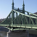
Liberty Bridge (aka Freedom Bridge, "Szabadság híd") - Boedapest, Hongarije
Wanneer u klikt:
Klik op de beelden!
-

The Liberty Bridge of Budapest ("Szabadság híd") over the Danube River and in front of the Gellért Hill ("Gellért-hegy")
Datum van het fotograferen: 20132013
Gemaakt door: Robert Németh
Cameramodel: Konica Minolta Dimage A200
Boedapest, Hongarije
-

The Pest-side tower (pylon) of the Liberty Bridge ("Szabadság híd") in front of the Gellért Hill
Datum van het fotograferen: 20132013
Gemaakt door: Robert Németh
Cameramodel: Konica Minolta Dimage A200
Boedapest, Hongarije
-

Former customs house at the Pest side of the Liberty Bridge ("Szabadság híd")
Datum van het fotograferen: 20132013
Gemaakt door: Robert Németh
Cameramodel: Konica Minolta Dimage A200
Boedapest, Hongarije
-

The sight of the Liberty Bridge ("Szabadság híd") and the Buda Castle Quarter from the promenade on the Danube bank in Pest
Datum van het fotograferen: 20132013
Gemaakt door: Robert Németh
Cameramodel: Konica Minolta Dimage A200
Boedapest, Hongarije
-

The view of the Liberty Bridge from the Pest bank of the Danube
Datum van het fotograferen: 20062006
Gemaakt door: Robert Németh
Cameramodel: Konica Minolta Dimage A200
Boedapest, Hongarije
-

The Liberty Bridge ("Szabadság híd") over the Danube River, as seen from the Gellért Hill
Datum van het fotograferen: 20112011
Gemaakt door: Robert Németh
Cameramodel: Konica Minolta Dimage A200
Boedapest, Hongarije
-

One of the ornate four-way lamp posts of the Liberty Bridge
In the background it is the Central Market Hall.
Datum van het fotograferen: 20132013
Gemaakt door: Robert Németh
Cameramodel: Konica Minolta Dimage A200
Boedapest, Hongarije
-

Ornate four-way lamp post on the Liberty Bridge ("Szabadság híd")
Datum van het fotograferen: 20132013
Gemaakt door: Robert Németh
Cameramodel: Konica Minolta Dimage A200
Boedapest, Hongarije
-

Some lamps of the Liberty Bridge
Datum van het fotograferen: 20132013
Gemaakt door: Robert Németh
Cameramodel: Konica Minolta Dimage A200
Boedapest, Hongarije
-

The other former customs house of the Liberty Bridge ("Szabadság híd"), in front of the main building of the Corvinus University
Datum van het fotograferen: 20132013
Gemaakt door: Robert Németh
Cameramodel: Konica Minolta Dimage A200
Boedapest, Hongarije
-
The foot of the Gellért Hill viewed from the Liberty Bridge ("Szabadság híd")
Datum van het fotograferen: 20132013
Gemaakt door: Robert Németh
Cameramodel: Konica Minolta Dimage A200
Boedapest, Hongarije
The foot of the Gellért Hill viewed from the Liberty Bridge ("Szabadság híd") - Boedapest, Hongarije -
The end of the Liberty Bridge ("Szabadság híd") and the lower embankment on the Pest side of the river
Datum van het fotograferen: 20132013
Gemaakt door: Robert Németh
Cameramodel: Konica Minolta Dimage A200
Boedapest, Hongarije
The end of the Liberty Bridge ("Szabadság híd") and the lower embankment on the Pest side of the river - Boedapest, Hongarije -
The Pest-side end of the Liberty Bridge ("Szabadság híd")
Datum van het fotograferen: 20132013
Gemaakt door: Robert Németh
Cameramodel: Konica Minolta Dimage A200
Boedapest, Hongarije
The Pest-side end of the Liberty Bridge ("Szabadság híd") - Boedapest, Hongarije -
The view of the Liberty Bridge ("Szabadság híd") towards Buda
Datum van het fotograferen: 20132013
Gemaakt door: Robert Németh
Cameramodel: Konica Minolta Dimage A200
Boedapest, Hongarije
The view of the Liberty Bridge ("Szabadság híd") towards Buda - Boedapest, Hongarije -
The connection of the Liberty Bridge ("Szabadság híd") on the Pest riverside
Datum van het fotograferen: 20132013
Gemaakt door: Robert Németh
Cameramodel: Konica Minolta Dimage A200
Boedapest, Hongarije
The connection of the Liberty Bridge ("Szabadság híd") on the Pest riverside - Boedapest, Hongarije -
The Pest-side end of the Liberty Bridge ("Szabadság híd"), and the main building of the Corvinus University in the background
Datum van het fotograferen: 20132013
Gemaakt door: Robert Németh
Cameramodel: Konica Minolta Dimage A200
Boedapest, Hongarije
The Pest-side end of the Liberty Bridge ("Szabadság híd"), and the main building of the Corvinus University in the background - Boedapest, Hongarije -
Passers-by on the Liberty Bridge ("Szabadság híd")
Datum van het fotograferen: 20132013
Gemaakt door: Robert Németh
Cameramodel: Konica Minolta Dimage A200
Boedapest, Hongarije
Passers-by on the Liberty Bridge ("Szabadság híd") - Boedapest, Hongarije -
A tram on the Liberty Bridge
Datum van het fotograferen: 20132013
Gemaakt door: Robert Németh
Cameramodel: Konica Minolta Dimage A200
Boedapest, Hongarije
A tram on the Liberty Bridge - Boedapest, Hongarije -
The sight from the Libery Bridge northwards: the Danube River, the Gellért Hill, the Elisabeth Bridge and the Buda Castle
Datum van het fotograferen: 20132013
Gemaakt door: Robert Németh
Cameramodel: Konica Minolta Dimage A200
Boedapest, Hongarije
The sight from the Libery Bridge northwards: the Danube River, the Gellért Hill, the Elisabeth Bridge and the Buda Castle - Boedapest, Hongarije -
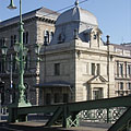
Old customs house, today museum with exhibition that presents the Danube bridges of Budapest
Datum van het fotograferen: 20132013
Gemaakt door: Robert Németh
Cameramodel: Konica Minolta Dimage A200
Boedapest, Hongarije
Old customs house, today museum with exhibition that presents the Danube bridges of Budapest - Boedapest, Hongarije -
Simplified coat of arms of Hungary on the Liberty Bridge ("Szabadság híd")
Datum van het fotograferen: 20132013
Gemaakt door: Robert Németh
Cameramodel: Konica Minolta Dimage A200
Boedapest, Hongarije
Simplified coat of arms of Hungary on the Liberty Bridge ("Szabadság híd") - Boedapest, Hongarije -
The Liberty Bridge ("Szabadság híd") to the direction of Buda
Datum van het fotograferen: 20132013
Gemaakt door: Robert Németh
Cameramodel: Konica Minolta Dimage A200
Boedapest, Hongarije
The Liberty Bridge ("Szabadság híd") to the direction of Buda - Boedapest, Hongarije -
Detail of the Liberty Bridge
Datum van het fotograferen: 20132013
Gemaakt door: Robert Németh
Cameramodel: Konica Minolta Dimage A200
Boedapest, Hongarije
Detail of the Liberty Bridge - Boedapest, Hongarije -
The green-painted Liberty Bridge ("Szabadság híd")
Datum van het fotograferen: 20132013
Gemaakt door: Robert Németh
Cameramodel: Konica Minolta Dimage A200
Boedapest, Hongarije
The green-painted Liberty Bridge ("Szabadság híd") - Boedapest, Hongarije -
The Pest-side pylon of the Libery Bridge ("Szabadság híd")
Datum van het fotograferen: 20132013
Gemaakt door: Robert Németh
Cameramodel: Konica Minolta Dimage A200
Boedapest, Hongarije
The Pest-side pylon of the Libery Bridge ("Szabadság híd") - Boedapest, Hongarije -
The surroundings of the Liberty Bridge on the Pest side of the river (embankment, Danube, bridge, etc.)
Datum van het fotograferen: 20132013
Gemaakt door: Robert Németh
Cameramodel: Konica Minolta Dimage A200
Boedapest, Hongarije
The surroundings of the Liberty Bridge on the Pest side of the river (embankment, Danube, bridge, etc.) - Boedapest, Hongarije -
A tower (pylon) of the Liberty Bridge ("Szabadság híd") with the bronze sculpture of a falcon-like turul bird, as well as the Libery Statue on the Gellért Hill (in the distance)
Datum van het fotograferen: 20132013
Gemaakt door: Robert Németh
Cameramodel: Konica Minolta Dimage A200
Boedapest, Hongarije
A tower (pylon) of the Liberty Bridge ("Szabadság híd") with the bronze sculpture of a falcon-like turul bird, as well as the Libery Statue on the Gellért Hill (in the distance) - Boedapest, Hongarije -
One of the towers (pylons) of the Liberty Bridge ("Szabadság híd") with two turul bird sculptures on its top, and the Liberty Statue on the Gellért Hill in the background
Datum van het fotograferen: 20132013
Gemaakt door: Robert Németh
Cameramodel: Konica Minolta Dimage A200
Boedapest, Hongarije
One of the towers (pylons) of the Liberty Bridge ("Szabadság híd") with two turul bird sculptures on its top, and the Liberty Statue on the Gellért Hill in the background - Boedapest, Hongarije -
The Pest-side lower embankment, as well as the Liberty Bridge ("Szabadság híd") over River Danube
Datum van het fotograferen: 20132013
Gemaakt door: Robert Németh
Cameramodel: Konica Minolta Dimage A200
Boedapest, Hongarije
The Pest-side lower embankment, as well as the Liberty Bridge ("Szabadság híd") over River Danube - Boedapest, Hongarije -
The Liberty Bridge ("Szabadság híd") over the river
Datum van het fotograferen: 20132013
Gemaakt door: Robert Németh
Cameramodel: Konica Minolta Dimage A200
Boedapest, Hongarije
The Liberty Bridge ("Szabadság híd") over the river - Boedapest, Hongarije -
Liberty Bridge ("Szabadság híd", formerly "Ferencz József híd", "Fővám téri híd") over River Danube
Datum van het fotograferen: 20062006
Gemaakt door: Robert Németh
Cameramodel: Konica Minolta Dimage A200
Boedapest, Hongarije
Liberty Bridge ("Szabadság híd", formerly "Ferencz József híd", "Fővám téri híd") over River Danube - Boedapest, Hongarije -
Liberty Bridge (in Hungarian "Szabadság híd"), as well as the Gellért Hotel and Gellért Bath in the distance
Datum van het fotograferen: 20062006
Gemaakt door: Robert Németh
Cameramodel: Konica Minolta Dimage A200
Boedapest, Hongarije
Liberty Bridge (in Hungarian "Szabadság híd"), as well as the Gellért Hotel and Gellért Bath in the distance - Boedapest, Hongarije -
Liberty Bridge ("Szabadság híd") over the flooded Danube, viewed from Gellért Hill
Datum van het fotograferen: 20062006
Gemaakt door: Robert Németh
Cameramodel: Konica Minolta Dimage A200
Boedapest, Hongarije
Liberty Bridge ("Szabadság híd") over the flooded Danube, viewed from Gellért Hill - Boedapest, Hongarije -
The Liberty Bridge ("Szabadság híd") and the flooding River Danube from Gellért Hill
Datum van het fotograferen: 20062006
Gemaakt door: Robert Németh
Cameramodel: Konica Minolta Dimage A200
Boedapest, Hongarije
The Liberty Bridge ("Szabadság híd") and the flooding River Danube from Gellért Hill - Boedapest, Hongarije -
Coat of arms of Hungary and sculptures of turul birds on the pylon (tower) of the Liberty Bridge or "Szabadság híd"
Datum van het fotograferen: 20062006
Gemaakt door: Robert Németh
Cameramodel: Konica Minolta Dimage A200
Boedapest, Hongarije
Coat of arms of Hungary and sculptures of turul birds on the pylon (tower) of the Liberty Bridge or "Szabadság híd" - Boedapest, Hongarije -
The view of the Buda-side embankment and the Hotel Gellért from the Liberty Bridge in the evening
Datum van het fotograferen: 20042004
Gemaakt door: Robert Németh
Cameramodel: Canon PowerShot A85
Boedapest, Hongarije
The view of the Buda-side embankment and the Hotel Gellért from the Liberty Bridge in the evening - Boedapest, Hongarije


Klik op de beelden!
Kenmerken, eigenschappen, karakteristieken
Ligging:
GPS-coördinaten: Breedtegraad 47°29'8", Lengtegraad 19°3'17" (N47 29.13 - E19 3.28)
Informatie, korte verhalen, interessante weetjes
 Liberty Bridge ("Szabadság híd", formerly "Ferencz József híd", "Fővám téri híd") over River Danube
The Liberty Bridge or Freedom Bridge (also known as Freedom Bridge, in Hungarian "Szabadság híd") or as it was called initially the Franz Joseph Bridge ("Ferencz József híd") was designed by János Feketeházy, it was opened in the year of the Hungarian Millenium in 1896. This was the third permanent road crossing over the Danube in Budapest. Even then the bridge already had tram tracks, as well as electric and gas lighting.
The first tram went throught the Liberty Bridge ("Szabadság híd") in 1898. At that time the tham tracks were on the sides of the bridge deck, and the tram used a conduit current collection system (the electric wires were on the ground) to get the power. The tram line was converted to overhead wire system in 1923, and from 1928 also the bus traffic was started on the bridge. Then in 1938 the rails were moved to the middle of the road, as it can be seen today.
Another characteristics of the Szabadság Bridge or Liberty Bridge are the statues of turul birds with outstretched wings on the top of the pylon gates that were designed by Virgil Nagy, as well as the historical Hungarian coat of arms on the gateways (all of them were made in 1896).
 Liberty Bridge ("Szabadság híd") over the flooded Danube, viewed from Gellért Hill
The Liberty Bridge (or Freedom Bridge, in Hungarian "Szabadság híd") is the shortest among the Danube bridges of Budapest. Before the World War II it was called Franz Joseph Bridge or Fővám Square Bridge ("Ferenc József híd" or "Fővám téri híd").
At the end of the World War II the bridge was blown up by the retreating German troops, like every other Danube bridge of Budapest. But the piers (more precisely the pylons) were remained intact and also the reparation of the middle section could be done relatively quickly. The reconstruction was done soon by the plans of Pál Sávoly architect, in 1946 it was already opened for service and then got its new name: "Szabadság híd" (in English "Liberty Bridge" or "Freedom Bridge").
Boedapest - Meer foto galleries:
U bent wellicht ook geïnteresseerd in (Verwante pagina's):
Bestemmingen in de reisgids:
Boedapest (8 468 foto's + 21 panoramische beelden)
Buda Hills (Budai-hegység) (8 632 foto's + 21 panoramische beelden)
Pest megye (county) (15 122 foto's + 50 panoramische beelden)
Boedapest en de omringende (15 989 foto's + 52 panoramische beelden)
Hongarije (27 287 foto's + 163 panoramische beelden)
en bovendien:
(hier binnen: Buda Hills)
Budakeszi (88 foto's)
Pilisszentiván (76 foto's)
Elke panoramische foto hier:
Boedapest (21 foto's)
Pest megye (county) (50 foto's)
Boedapest en de omringende (52 foto's)
Hongarije (163 foto's)
Europa (165 foto's)
Elke normale foto hier:
Boedapest (8 468 foto's / 122 galerijen)
Buda Hills (Budai-hegység) (8 632 foto's / 124 galerijen)
Pest megye (county) (15 122 foto's / 221 galerijen)
Boedapest en de omringende (15 989 foto's / 234 galerijen)
Hongarije (27 287 foto's / 462 galerijen)
Europa (30 494 foto's / 523 galerijen)
https://www.panadea.com/nl/guidebook/boedapest/photos/gal-014

Voeg toe aan Favorieten Toevoegen aan Bladwijzers
Deel met je vrienden!
enz.


Onze reisgids bevat:
Een groot aantal foto's en panoramische beelden, met veel informatie en interessante feiten.
- 214 reisbestemmingen
- 165 panoramische beelden
- 30 494 andere foto's
Grote verzameling van geselecteerde foto's: uitstekende kwaliteit, hoge resolutie en natuurlijke kleuren
Over ons - Vrijwaringsclausule -
Alle rechten voorbehouden
- ©2010-2022
Neuronit Creative Studio - Mogyoród / Boedapest / Hongarije