
(Optimalizované pro zařízení s malou obrazovkou)
Újpest, district center - Budapešť, Maďarsko
Když klepnete:
Klikněte na obrázky!
-

The eclectic-secession style Town Hall of Újpest was built in 1900
The former Village Hall (that was on the site of the current Town Hall) was built in 1845, by public subscription.
Datum fotografie: 20132013
Vytvořil: Robert Németh
Model fotoaparátu: Konica Minolta Dimage A200
Budapešť, Maďarsko
-

The first Roman Catholic church of Újpest, the "Queen of Heaven" Church
Datum fotografie: 20132013
Vytvořil: Robert Németh
Model fotoaparátu: Konica Minolta Dimage A200
Budapešť, Maďarsko
-

Fountains near the Town Hall
Datum fotografie: 20132013
Vytvořil: Robert Németh
Model fotoaparátu: Konica Minolta Dimage A200
Budapešť, Maďarsko
-

Park with passersby
Datum fotografie: 20132013
Vytvořil: Robert Németh
Model fotoaparátu: Konica Minolta Dimage A200
Budapešť, Maďarsko
-

Entrance of the market from the Small Market Hall
Datum fotografie: 20132013
Vytvořil: Robert Németh
Model fotoaparátu: Konica Minolta Dimage A200
Budapešť, Maďarsko
-

People waiting for the tram in the stop
Datum fotografie: 20132013
Vytvořil: Robert Németh
Model fotoaparátu: Konica Minolta Dimage A200
Budapešť, Maďarsko
-

Tram stop
Datum fotografie: 20132013
Vytvořil: Robert Németh
Model fotoaparátu: Konica Minolta Dimage A200
Budapešť, Maďarsko
-

Tram station and the State Department Store of Újpest ("Újpesti Állami Áruház")
Datum fotografie: 20132013
Vytvořil: Robert Németh
Model fotoaparátu: Konica Minolta Dimage A200
Budapešť, Maďarsko
-

A yellow building and the tram stop
Datum fotografie: 20132013
Vytvořil: Robert Németh
Model fotoaparátu: Konica Minolta Dimage A200
Budapešť, Maďarsko
-

Relief on a yellow building
Datum fotografie: 20132013
Vytvořil: Robert Németh
Model fotoaparátu: Konica Minolta Dimage A200
Budapešť, Maďarsko
-
The State Department Store of Újpest (in Hungarian "Újpesti Állami Áruház")
Although the filming itself wasn't happened here, the "Állami Áruház" ("State Department Store") Hungarian movie from 1952 is set in the Újpest Department Store (in Hungarian "Újpesti Áruház"), starring among others Kálmán Latabár and Ida Turay, directed by Viktor Gertler, film scores and songs by Iván Szenes and Szabolcs Fényes Hungarian composers.
Datum fotografie: 20132013
Vytvořil: Robert Németh
Model fotoaparátu: Konica Minolta Dimage A200
Budapešť, Maďarsko
The State Department Store of Újpest (in Hungarian "Újpesti Állami Áruház") - Budapešť, Maďarsko -
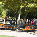
New benches with plane trees in the public park
Datum fotografie: 20132013
Vytvořil: Robert Németh
Model fotoaparátu: Konica Minolta Dimage A200
Budapešť, Maďarsko
New benches with plane trees in the public park - Budapešť, Maďarsko -
New benches in the park beside the Town Hall
Datum fotografie: 20132013
Vytvořil: Robert Németh
Model fotoaparátu: Konica Minolta Dimage A200
Budapešť, Maďarsko
New benches in the park beside the Town Hall - Budapešť, Maďarsko -
People in the bus stop, and a tram
Datum fotografie: 20132013
Vytvořil: Robert Németh
Model fotoaparátu: Konica Minolta Dimage A200
Budapešť, Maďarsko
People in the bus stop, and a tram - Budapešť, Maďarsko -
The Our Lady Queen of Heaven Church was built between 1875 and 1881
Datum fotografie: 20132013
Vytvořil: Robert Németh
Model fotoaparátu: Konica Minolta Dimage A200
Budapešť, Maďarsko
The Our Lady Queen of Heaven Church was built between 1875 and 1881 - Budapešť, Maďarsko -
The steeple with the spire of the Our Lady Queen of Heaven Church
Datum fotografie: 20132013
Vytvořil: Robert Németh
Model fotoaparátu: Konica Minolta Dimage A200
Budapešť, Maďarsko
The steeple with the spire of the Our Lady Queen of Heaven Church - Budapešť, Maďarsko -
The Roman Catholic Parish Church is dedicated to the "Queen of Heaven" (who is actually Mother Mary)
Datum fotografie: 20132013
Vytvořil: Robert Németh
Model fotoaparátu: Konica Minolta Dimage A200
Budapešť, Maďarsko
The Roman Catholic Parish Church is dedicated to the "Queen of Heaven" (who is actually Mother Mary) - Budapešť, Maďarsko -
The "Queen of Heaven" (in Hungarian "Egek királynéja") Roman Catholic Parish Church
Datum fotografie: 20132013
Vytvořil: Robert Németh
Model fotoaparátu: Konica Minolta Dimage A200
Budapešť, Maďarsko
The "Queen of Heaven" (in Hungarian "Egek királynéja") Roman Catholic Parish Church - Budapešť, Maďarsko -
A statue in the park behind the Town Hall, named as the "Sorrowful mother" or the "Mother's pain"
Datum fotografie: 20132013
Vytvořil: Robert Németh
Model fotoaparátu: Konica Minolta Dimage A200
Budapešť, Maďarsko
A statue in the park behind the Town Hall, named as the "Sorrowful mother" or the "Mother's pain" - Budapešť, Maďarsko -
The "Sorrowful mother" or the "Mother's pain" statue is in fact a Treaty of Trianon Memorial
Datum fotografie: 20132013
Vytvořil: Robert Németh
Model fotoaparátu: Konica Minolta Dimage A200
Budapešť, Maďarsko
The "Sorrowful mother" or the "Mother's pain" statue is in fact a Treaty of Trianon Memorial - Budapešť, Maďarsko -
The "Sorrowful mother" or the "Mother's pain" statue
This artwork of András Kocsis Hungarian sculptor is standing in the main square since 1937, except between 2003-2010.
Datum fotografie: 20132013
Vytvořil: Robert Németh
Model fotoaparátu: Konica Minolta Dimage A200
Budapešť, Maďarsko
The "Sorrowful mother" or the "Mother's pain" statue - Budapešť, Maďarsko -
The "Downtown" Reformed Church in Újpest
Datum fotografie: 20132013
Vytvořil: Robert Németh
Model fotoaparátu: Konica Minolta Dimage A200
Budapešť, Maďarsko
The "Downtown" Reformed Church in Újpest - Budapešť, Maďarsko -
An older residential building
Datum fotografie: 20132013
Vytvořil: Robert Németh
Model fotoaparátu: Konica Minolta Dimage A200
Budapešť, Maďarsko
An older residential building - Budapešť, Maďarsko -
The east side of the
Datum fotografie: 20132013
Vytvořil: Robert Németh
Model fotoaparátu: Konica Minolta Dimage A200
Budapešť, Maďarsko
The east side of the - Budapešť, Maďarsko -
(Our Lady) "Queen of Heaven" Roman Catholic Church
Datum fotografie: 20132013
Vytvořil: Robert Németh
Model fotoaparátu: Konica Minolta Dimage A200
Budapešť, Maďarsko
(Our Lady) "Queen of Heaven" Roman Catholic Church - Budapešť, Maďarsko -
(Our Lady) "Queen of Heaven" Roman Catholic Church
Datum fotografie: 20132013
Vytvořil: Robert Németh
Model fotoaparátu: Konica Minolta Dimage A200
Budapešť, Maďarsko
(Our Lady) "Queen of Heaven" Roman Catholic Church - Budapešť, Maďarsko -
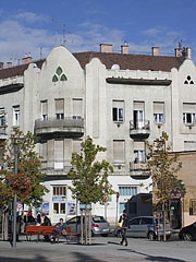
An older residental building with nice decorations on its facade
Datum fotografie: 20132013
Vytvořil: Robert Németh
Model fotoaparátu: Konica Minolta Dimage A200
Budapešť, Maďarsko
An older residental building with nice decorations on its facade - Budapešť, Maďarsko -
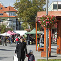
Autumn mood in the Szent István Square (the former Piac Square, which meant "market square")
Datum fotografie: 20132013
Vytvořil: Robert Németh
Model fotoaparátu: Konica Minolta Dimage A200
Budapešť, Maďarsko
Autumn mood in the Szent István Square (the former Piac Square, which meant "market square") - Budapešť, Maďarsko -
The "Újpest-downtown" Reformed Church
Datum fotografie: 20132013
Vytvořil: Robert Németh
Model fotoaparátu: Konica Minolta Dimage A200
Budapešť, Maďarsko
The "Újpest-downtown" Reformed Church - Budapešť, Maďarsko -
City Hall, main entrance
Datum fotografie: 20132013
Vytvořil: Robert Németh
Model fotoaparátu: Konica Minolta Dimage A200
Budapešť, Maďarsko
City Hall, main entrance - Budapešť, Maďarsko -
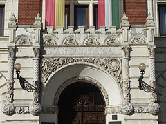
The decoration on the main entrance of the Town Hall
Datum fotografie: 20132013
Vytvořil: Robert Németh
Model fotoaparátu: Konica Minolta Dimage A200
Budapešť, Maďarsko
The decoration on the main entrance of the Town Hall - Budapešť, Maďarsko -
The upper section on the front wall of the Town Hall
Datum fotografie: 20132013
Vytvořil: Robert Németh
Model fotoaparátu: Konica Minolta Dimage A200
Budapešť, Maďarsko
The upper section on the front wall of the Town Hall - Budapešť, Maďarsko -
Bronze statue on the top of the Town Hall of Újpest
Datum fotografie: 20132013
Vytvořil: Robert Németh
Model fotoaparátu: Konica Minolta Dimage A200
Budapešť, Maďarsko
Bronze statue on the top of the Town Hall of Újpest - Budapešť, Maďarsko -
City Hall of Újpest, balcony
Datum fotografie: 20132013
Vytvořil: Robert Németh
Model fotoaparátu: Konica Minolta Dimage A200
Budapešť, Maďarsko
City Hall of Újpest, balcony - Budapešť, Maďarsko -
City Hall of Újpest, windows of the building
Datum fotografie: 20132013
Vytvořil: Robert Németh
Model fotoaparátu: Konica Minolta Dimage A200
Budapešť, Maďarsko
City Hall of Újpest, windows of the building - Budapešť, Maďarsko -
City Hall of Újpest, windows
Datum fotografie: 20132013
Vytvořil: Robert Németh
Model fotoaparátu: Konica Minolta Dimage A200
Budapešť, Maďarsko
City Hall of Újpest, windows - Budapešť, Maďarsko -
City Hall of Újpest, carved decorations around the windows
Datum fotografie: 20132013
Vytvořil: Robert Németh
Model fotoaparátu: Konica Minolta Dimage A200
Budapešť, Maďarsko
City Hall of Újpest, carved decorations around the windows - Budapešť, Maďarsko -
Szent István (Saint Stephen of Hungary) office building and business center
Datum fotografie: 20132013
Vytvořil: Robert Németh
Model fotoaparátu: Konica Minolta Dimage A200
Budapešť, Maďarsko
Szent István (Saint Stephen of Hungary) office building and business center - Budapešť, Maďarsko -
Pharmacy on the ground floor of the Szent István business center
Datum fotografie: 20132013
Vytvořil: Robert Németh
Model fotoaparátu: Konica Minolta Dimage A200
Budapešť, Maďarsko
Pharmacy on the ground floor of the Szent István business center - Budapešť, Maďarsko -
The "Újpest-downtown" Reformed Church
Datum fotografie: 20132013
Vytvořil: Robert Németh
Model fotoaparátu: Konica Minolta Dimage A200
Budapešť, Maďarsko
The "Újpest-downtown" Reformed Church - Budapešť, Maďarsko -
Entrance of the market from the Small Market Hall (in Hungarian "Kiscsarnok")
Datum fotografie: 20132013
Vytvořil: Robert Németh
Model fotoaparátu: Konica Minolta Dimage A200
Budapešť, Maďarsko
Entrance of the market from the Small Market Hall (in Hungarian "Kiscsarnok") - Budapešť, Maďarsko -
Entrance of the market from the Small Market Hall
Datum fotografie: 20132013
Vytvořil: Robert Németh
Model fotoaparátu: Konica Minolta Dimage A200
Budapešť, Maďarsko
Entrance of the market from the Small Market Hall - Budapešť, Maďarsko -
Small Market Hall, butcher shop
Datum fotografie: 20132013
Vytvořil: Robert Németh
Model fotoaparátu: Konica Minolta Dimage A200
Budapešť, Maďarsko
Small Market Hall, butcher shop - Budapešť, Maďarsko -
Small Market Hall, a greengrocer's stand in the marked
Datum fotografie: 20132013
Vytvořil: Robert Németh
Model fotoaparátu: Konica Minolta Dimage A200
Budapešť, Maďarsko
Small Market Hall, a greengrocer's stand in the marked - Budapešť, Maďarsko -
Small Market Hall, fruit and vegetable stand
Datum fotografie: 20132013
Vytvořil: Robert Németh
Model fotoaparátu: Konica Minolta Dimage A200
Budapešť, Maďarsko
Small Market Hall, fruit and vegetable stand - Budapešť, Maďarsko -
Small Market Hall, fruits and vegetables
Datum fotografie: 20132013
Vytvořil: Robert Németh
Model fotoaparátu: Konica Minolta Dimage A200
Budapešť, Maďarsko
Small Market Hall, fruits and vegetables - Budapešť, Maďarsko -
Small Market Hall, meat counter with
Datum fotografie: 20132013
Vytvořil: Robert Németh
Model fotoaparátu: Konica Minolta Dimage A200
Budapešť, Maďarsko
Small Market Hall, meat counter with - Budapešť, Maďarsko -
Butcher's shop in the Small Market Hall
Datum fotografie: 20132013
Vytvořil: Robert Németh
Model fotoaparátu: Konica Minolta Dimage A200
Budapešť, Maďarsko
Butcher's shop in the Small Market Hall - Budapešť, Maďarsko -
The butcher's stand in the marketplace
Datum fotografie: 20132013
Vytvořil: Robert Németh
Model fotoaparátu: Konica Minolta Dimage A200
Budapešť, Maďarsko
The butcher's stand in the marketplace - Budapešť, Maďarsko -
Meat counter in the marketplace
Datum fotografie: 20132013
Vytvořil: Robert Németh
Model fotoaparátu: Konica Minolta Dimage A200
Budapešť, Maďarsko
Meat counter in the marketplace - Budapešť, Maďarsko -
Our Lady "Queen of Heaven" Roman Catholic Parish Church
Datum fotografie: 20132013
Vytvořil: Robert Németh
Model fotoaparátu: Konica Minolta Dimage A200
Budapešť, Maďarsko
Our Lady "Queen of Heaven" Roman Catholic Parish Church - Budapešť, Maďarsko -
A statue on the Catholic Church in the Szent István Square
Datum fotografie: 20132013
Vytvořil: Robert Németh
Model fotoaparátu: Konica Minolta Dimage A200
Budapešť, Maďarsko
A statue on the Catholic Church in the Szent István Square - Budapešť, Maďarsko -
One of the later attached side aisles of the "Queen of Heaven" Roman Catholic Church (it was built sometime before the World War I)
Datum fotografie: 20132013
Vytvořil: Robert Németh
Model fotoaparátu: Konica Minolta Dimage A200
Budapešť, Maďarsko
One of the later attached side aisles of the "Queen of Heaven" Roman Catholic Church (it was built sometime before the World War I) - Budapešť, Maďarsko -
Wooden benched in the park beside the Catholic Church
Datum fotografie: 20132013
Vytvořil: Robert Németh
Model fotoaparátu: Konica Minolta Dimage A200
Budapešť, Maďarsko
Wooden benched in the park beside the Catholic Church - Budapešť, Maďarsko -
The wooden sculpture looks like a stylized gate
Datum fotografie: 20132013
Vytvořil: Robert Németh
Model fotoaparátu: Konica Minolta Dimage A200
Budapešť, Maďarsko
The wooden sculpture looks like a stylized gate - Budapešť, Maďarsko -
The tower or steeple of the Our Lady "Queen of Heaven" Roman Catholic Church
Datum fotografie: 20132013
Vytvořil: Robert Németh
Model fotoaparátu: Konica Minolta Dimage A200
Budapešť, Maďarsko
The tower or steeple of the Our Lady "Queen of Heaven" Roman Catholic Church - Budapešť, Maďarsko -
The tower or steeple of the Our Lady "Queen of Heaven" Roman Catholic Parish Church
Datum fotografie: 20132013
Vytvořil: Robert Németh
Model fotoaparátu: Konica Minolta Dimage A200
Budapešť, Maďarsko
The tower or steeple of the Our Lady "Queen of Heaven" Roman Catholic Parish Church - Budapešť, Maďarsko -
Park near the market
Datum fotografie: 20132013
Vytvořil: Robert Németh
Model fotoaparátu: Konica Minolta Dimage A200
Budapešť, Maďarsko
Park near the market - Budapešť, Maďarsko -
Park at the market
Datum fotografie: 20132013
Vytvořil: Robert Németh
Model fotoaparátu: Konica Minolta Dimage A200
Budapešť, Maďarsko
Park at the market - Budapešť, Maďarsko -
The western side of Town Hall
Datum fotografie: 20132013
Vytvořil: Robert Németh
Model fotoaparátu: Konica Minolta Dimage A200
Budapešť, Maďarsko
The western side of Town Hall - Budapešť, Maďarsko -
Statue of Count István Károlyi
Datum fotografie: 20132013
Vytvořil: Robert Németh
Model fotoaparátu: Konica Minolta Dimage A200
Budapešť, Maďarsko
Statue of Count István Károlyi - Budapešť, Maďarsko -
Memorial of Count István Károlyi
The bronze statue in the park near the Town Hall in the Szent István Square represents Count István Károlyi (1797-1881), founder of Újpest, as well as politician and academic. In 1840 he founded Új-Megyer village, the predecessor of Újpest (which is a former village and town, today district). The monument was created by Iván Paulikovics in 1997.
Datum fotografie: 20132013
Vytvořil: Robert Németh
Model fotoaparátu: Konica Minolta Dimage A200
Budapešť, Maďarsko
Memorial of Count István Károlyi - Budapešť, Maďarsko -
Newsstand near the Town Hall
Datum fotografie: 20132013
Vytvořil: Robert Németh
Model fotoaparátu: Konica Minolta Dimage A200
Budapešť, Maďarsko
Newsstand near the Town Hall - Budapešť, Maďarsko -
Newsagent's shop (or newsstand) at the Town Hall
Datum fotografie: 20132013
Vytvořil: Robert Németh
Model fotoaparátu: Konica Minolta Dimage A200
Budapešť, Maďarsko
Newsagent's shop (or newsstand) at the Town Hall - Budapešť, Maďarsko -
Town Hall
Datum fotografie: 20132013
Vytvořil: Robert Németh
Model fotoaparátu: Konica Minolta Dimage A200
Budapešť, Maďarsko
Town Hall - Budapešť, Maďarsko -
Windows of the Town Hall
Datum fotografie: 20132013
Vytvořil: Robert Németh
Model fotoaparátu: Konica Minolta Dimage A200
Budapešť, Maďarsko
Windows of the Town Hall - Budapešť, Maďarsko -
A confectionery on the ground floor of a building, which is just under renovation
Datum fotografie: 20132013
Vytvořil: Robert Németh
Model fotoaparátu: Konica Minolta Dimage A200
Budapešť, Maďarsko
A confectionery on the ground floor of a building, which is just under renovation - Budapešť, Maďarsko -
Show-window of a confectionery
Datum fotografie: 20132013
Vytvořil: Robert Németh
Model fotoaparátu: Konica Minolta Dimage A200
Budapešť, Maďarsko
Show-window of a confectionery - Budapešť, Maďarsko -
Pastries and bakery products in the show-window of the confectionery
Datum fotografie: 20132013
Vytvořil: Robert Németh
Model fotoaparátu: Konica Minolta Dimage A200
Budapešť, Maďarsko
Pastries and bakery products in the show-window of the confectionery - Budapešť, Maďarsko -
A zebra crossing (pedestrian crosswalk) and a blue bus
Datum fotografie: 20132013
Vytvořil: Robert Németh
Model fotoaparátu: Konica Minolta Dimage A200
Budapešť, Maďarsko
A zebra crossing (pedestrian crosswalk) and a blue bus - Budapešť, Maďarsko -
A house under renovation
Datum fotografie: 20132013
Vytvořil: Robert Németh
Model fotoaparátu: Konica Minolta Dimage A200
Budapešť, Maďarsko
A house under renovation - Budapešť, Maďarsko -
Town Hall of Újpest
Datum fotografie: 20132013
Vytvořil: Robert Németh
Model fotoaparátu: Konica Minolta Dimage A200
Budapešť, Maďarsko
Town Hall of Újpest - Budapešť, Maďarsko -
A blue bus on the István Road
Datum fotografie: 20132013
Vytvořil: Robert Németh
Model fotoaparátu: Konica Minolta Dimage A200
Budapešť, Maďarsko
A blue bus on the István Road - Budapešť, Maďarsko -
Main square with flowers and the Protestant (Reformed) church
Datum fotografie: 20132013
Vytvořil: Robert Németh
Model fotoaparátu: Konica Minolta Dimage A200
Budapešť, Maďarsko
Main square with flowers and the Protestant (Reformed) church - Budapešť, Maďarsko -
The Town Hall of Újpest, with tram tracks in the foreground
Datum fotografie: 20132013
Vytvořil: Robert Németh
Model fotoaparátu: Konica Minolta Dimage A200
Budapešť, Maďarsko
The Town Hall of Újpest, with tram tracks in the foreground - Budapešť, Maďarsko -
Town Hall of Újpest
Datum fotografie: 20132013
Vytvořil: Robert Németh
Model fotoaparátu: Konica Minolta Dimage A200
Budapešť, Maďarsko
Town Hall of Újpest - Budapešť, Maďarsko -
Document bureau (or document office)
Datum fotografie: 20132013
Vytvořil: Robert Németh
Model fotoaparátu: Konica Minolta Dimage A200
Budapešť, Maďarsko
Document bureau (or document office) - Budapešť, Maďarsko -
The front face of the Town Hall
Datum fotografie: 20132013
Vytvořil: Robert Németh
Model fotoaparátu: Konica Minolta Dimage A200
Budapešť, Maďarsko
The front face of the Town Hall - Budapešť, Maďarsko -
Fountains and flags in the main square
Datum fotografie: 20132013
Vytvořil: Robert Németh
Model fotoaparátu: Konica Minolta Dimage A200
Budapešť, Maďarsko
Fountains and flags in the main square - Budapešť, Maďarsko -
Fountain in the main square, in front of the Reformed church
Datum fotografie: 20132013
Vytvořil: Robert Németh
Model fotoaparátu: Konica Minolta Dimage A200
Budapešť, Maďarsko
Fountain in the main square, in front of the Reformed church - Budapešť, Maďarsko -
The "Újpest-downtown" Reformed (Protestant) Church was built in 1878
Datum fotografie: 20132013
Vytvořil: Robert Németh
Model fotoaparátu: Konica Minolta Dimage A200
Budapešť, Maďarsko
The "Újpest-downtown" Reformed (Protestant) Church was built in 1878 - Budapešť, Maďarsko -
Town Hall of Újpest, main entrance
Datum fotografie: 20132013
Vytvořil: Robert Németh
Model fotoaparátu: Konica Minolta Dimage A200
Budapešť, Maďarsko
Town Hall of Újpest, main entrance - Budapešť, Maďarsko -
The area in front of the Town Hall
Datum fotografie: 20132013
Vytvořil: Robert Németh
Model fotoaparátu: Konica Minolta Dimage A200
Budapešť, Maďarsko
The area in front of the Town Hall - Budapešť, Maďarsko -
Interior of the Town Hall
Datum fotografie: 20132013
Vytvořil: Robert Németh
Model fotoaparátu: Konica Minolta Dimage A200
Budapešť, Maďarsko
Interior of the Town Hall - Budapešť, Maďarsko -
The columned lobby of the Town Hall
Datum fotografie: 20132013
Vytvořil: Robert Németh
Model fotoaparátu: Konica Minolta Dimage A200
Budapešť, Maďarsko
The columned lobby of the Town Hall - Budapešť, Maďarsko -
The pillared entrance hall of the Town Hall
Datum fotografie: 20132013
Vytvořil: Robert Németh
Model fotoaparátu: Konica Minolta Dimage A200
Budapešť, Maďarsko
The pillared entrance hall of the Town Hall - Budapešť, Maďarsko -
West facade of the Town Hall ("Városháza")
Datum fotografie: 20132013
Vytvořil: Robert Németh
Model fotoaparátu: Konica Minolta Dimage A200
Budapešť, Maďarsko
West facade of the Town Hall ("Városháza") - Budapešť, Maďarsko -
The park behind the Town Hall and the Roman Catholic church
Datum fotografie: 20132013
Vytvořil: Robert Németh
Model fotoaparátu: Konica Minolta Dimage A200
Budapešť, Maďarsko
The park behind the Town Hall and the Roman Catholic church - Budapešť, Maďarsko -
Benches in the park and traffic on the road
Datum fotografie: 20132013
Vytvořil: Robert Németh
Model fotoaparátu: Konica Minolta Dimage A200
Budapešť, Maďarsko
Benches in the park and traffic on the road - Budapešť, Maďarsko -
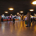
Pedestrian subway az Újpest Center ("Újpest-Központ")
Datum fotografie: 15. 11. 20142014
Vytvořil: Robert Németh
Model fotoaparátu: Konica Minolta Dimage A200
Budapešť, Maďarsko
Pedestrian subway az Újpest Center ("Újpest-Központ") - Budapešť, Maďarsko -
"Újpest-Központ" ("Újpest Center") pedestrian underpass with the northern terminal of the M3 (blue) metro line
Datum fotografie: 15. 11. 20142014
Vytvořil: Robert Németh
Model fotoaparátu: Konica Minolta Dimage A200
Budapešť, Maďarsko
"Újpest-Központ" ("Újpest Center") pedestrian underpass with the northern terminal of the M3 (blue) metro line - Budapešť, Maďarsko -
Újpest Center pedestrian subway (including the "TRIO" pizzeria and burger bar)
Datum fotografie: 15. 11. 20142014
Vytvořil: Robert Németh
Model fotoaparátu: Konica Minolta Dimage A200
Budapešť, Maďarsko
Újpest Center pedestrian subway (including the "TRIO" pizzeria and burger bar) - Budapešť, Maďarsko -
Renovated residental building on the main square with the "Központ Bisztró" café & bar downstairs
Datum fotografie: 15. 11. 20142014
Vytvořil: Robert Németh
Model fotoaparátu: Konica Minolta Dimage A200
Budapešť, Maďarsko
Renovated residental building on the main square with the "Központ Bisztró" café & bar downstairs - Budapešť, Maďarsko -
The renovated "Központ Bisztró" café & bar on the main square
Datum fotografie: 15. 11. 20142014
Vytvořil: Robert Németh
Model fotoaparátu: Konica Minolta Dimage A200
Budapešť, Maďarsko
The renovated "Központ Bisztró" café & bar on the main square - Budapešť, Maďarsko -
The renewed "Központ Bisztró" café & bar on the main square
Datum fotografie: 15. 11. 20142014
Vytvořil: Robert Németh
Model fotoaparátu: Konica Minolta Dimage A200
Budapešť, Maďarsko
The renewed "Központ Bisztró" café & bar on the main square - Budapešť, Maďarsko -
The renovated "Harangvirág" Confectionery
Datum fotografie: 15. 11. 20142014
Vytvořil: Robert Németh
Model fotoaparátu: Konica Minolta Dimage A200
Budapešť, Maďarsko
The renovated "Harangvirág" Confectionery - Budapešť, Maďarsko -
The shop-window of the "Harangvirág" Confectionery with cakes on display
Datum fotografie: 15. 11. 20142014
Vytvořil: Robert Németh
Model fotoaparátu: Konica Minolta Dimage A200
Budapešť, Maďarsko
The shop-window of the "Harangvirág" Confectionery with cakes on display - Budapešť, Maďarsko


Klikněte na obrázky!
Charakteristiky, vlastnosti
Umístění:
GPS souřadnice: Šířky 47°33'40", Délky 19°5'24" (N47 33.67 - E19 5.4)
Informace, krátké příběhy, zajímavosti
 The Town Hall of Újpest, with tram tracks in the foreground
Although at that time (and until 1950) Újpest was a standalone settlement separated from Budapest there were already tram tracks in front of the Town Hall since 1896. This tram line was the so-called "BÚR-railway", after the name of the Budapest-Újpest-Rákospalota Electric Railway ("BURV") transport company. The vehicles were made by the Hungarian Ganz factory, the style of the tram cars was quite similar to the also Ganz-made trams of Pozsony (today Bratislava, Slovakia) and Miskolc, which lines were started about the same time. Nowadays the yellow trams of the Line 12 and Line 14 of the Budapest Transport Company ("BKV Zrt.") can be seen at the Town Hall on the István Road.
Budapešť - Další fotogalerie:
Ty by mohly být také zájem o (Související stránky):
Destinací v průvodci:
Budapešť (8 468 fotky + 21 panoramatický fotky)
Budínské vrchy (Budai-hegység) (8 632 fotky + 21 panoramatický fotky)
Pest megye (county) (15 122 fotky + 50 panoramatický fotky)
Budapešti a jeho okolí (15 989 fotky + 52 panoramatický fotky)
Maďarsko (27 287 fotky + 163 panoramatický fotky)
a kromě toho:
(v rámci zde: Budínské vrchy)
Budakeszi (88 fotky)
Pilisszentiván (76 fotky)
Každý panorama foto zde:
Budapešť (21 fotky)
Pest megye (county) (50 fotky)
Budapešti a jeho okolí (52 fotky)
Maďarsko (163 fotky)
Evropa (165 fotky)
Všechny normální fotografie zde:
Budapešť (8 468 fotky / 122 galerie)
Budínské vrchy (Budai-hegység) (8 632 fotky / 124 galerie)
Pest megye (county) (15 122 fotky / 221 galerie)
Budapešti a jeho okolí (15 989 fotky / 234 galerie)
Maďarsko (27 287 fotky / 462 galerie)
Evropa (30 494 fotky / 523 galerie)
https://www.panadea.com/cs/guidebook/budapest/photos/gal-078

Přidat k Oblíbeným Přidat do Záložek
Sdílejte se svými přáteli!
atd.


Naš cestovní průvodce obsahuje:
Četné fotografie a panoramatické obrázky, se spoustou informací a zajímavosti.
- 214 turistické destinací
- 165 panoramatický fotky
- 30 494 další fotky
Velká sbírka vybraných fotografií: vynikající kvalita, vysoké rozlišení a přirozené barvy
Všechna práva vyhrazena
- ©2010-2022
Neuronit Creative Studio - Mogyoród / Budapešť / Maďarsko